Nasa reveals what Earth would look like with no SEA – uncovering Britain’s lost lands
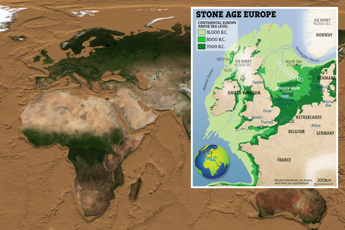
AN AMAZING animation shows what Earth would look like if we drained its oceans.Crafted by Nasa, the clip provides a glimpse of vast lands on the outer edges of Britain that were lost to the sea as recently as 12,000 years ago. An amazing Nasa animation shows what Earth would look like if we drained its oceans. The clip begins with a map of our planet showing its continents as we know them todayCredit: Nasa/Horace MitchellKnown as "Doggerland", the ancient land bridge would have once allowed humans and wildlife to walk between the UK and mainland Europe."Three fifths of the Earth's surface is under the ocean, and the ocean floor is as rich in detail as the land surface with which we are familiar," Nasa said."This animation simulates a drop in sea level that gradually reveals this detail."Published in 2008, the video begins with a map of Earth showing its continents as we know them today. Gradually, the sea level is lowered to reveal lost regions of land submerged under the sea. Pictured is what Earth would look like if the sea level dropped 500 metresCredit: Nasa/Horace MitchellMid-ocean ridges start to appear at a depth of 2,000 to 3,000 metersCredit: Nasa/Horace MitchellWith each passing second, the sea level drops by tens of metres to reveal the hidden prehistoric lands of our planet.First to pop up are the continental shelves large slabs around a continent's edge that are submerged under relatively shallow waters.Doggerland is part of one such shelf, and is thought to have been slowly submerged by water between 18,000BC and 5,500BC.Also known as "Britains Atlantis", it was an inhabited landscape stretching from Scotland to Denmark and down the English Channel. Once the water level hits 10,000 metres below sea level, only Earth's deepest ocean trenches remainCredit: Nasa/Horace MitchellMost of the tens of thousands of prehistoric Brits who lived there are said to have been killed by a devastating tsunami 8,200 years ago.Other continental shelves are also visible in the video, including those along stretches of the east coast of the United States.It's thought that a continental shelf between Alaska and Russia, known today as the Bering Strait, allowed early humans to cross to the Americas from east Asia during the last Ice Age."As the sea level drops, the continental shelves appear immediately," Nasa said of its video.What was it like in Britain during the Stone Age?Here's what you need to know about our prehistoric ancestors...The Stone Age was a prehistoric period in which ancient people mostly used stone to create toolsIt lasted for around 3.4 million years and ended around 8700 to 2000 BCIt was followed by the Bronze AgeAt the British "Atlantis" settlements the Stone Age people could have been hunting all sorts of animals from deer and wild cattle to seals and fishThe area would have been covered in rich grasslands with lot of plants to gather and a variety of bird eggs to collectStone Age people mostly used stone tools and spears but also made baskets from reeds and wore animal skins for warmthStone Henge is one of Britian's most famous sites and is an example of late Stone Age ceremonial practices"They are mostly visible by a depth of 140 meters, except for the Arctic and Antarctic regions, where the shelves are deeper."By 6,000 meters, most of the ocean is drained except for the deep ocean trenches.These are among the most poorly studied regions on Earth, with many still unexplored by humans.The deepest ocean trench is the Pacific Ocean's Marianas Trench at a depth of 10,911 meters.Stone Age living at the Outback2Basics site in StaffordshireIn other news, the remains of a medieval man who had his skull shattered have been found under a British church.The "worlds first Cheerios" have been discovered after 3,000-year-old "cereal rings" were found buried in an ancient fort.And, a "missing link" in human evolution has been found after 30,000-year-old remains were dug up.What do you think of the map? Let us know in the comments...We pay for your stories! Do you have a story for The Sun Online Tech & Science team? Email us at tech@the-sun.co.uk
……UK Ocean News

One-stop lifestyle app dedicated to making life in Singapore a breeze!


 English
 简体中文
简体中文
Comments
Leave a comment in Nestia App