Berlayer Creek mangroves and Sentosa’s Tanjong Rimau among nature spots at risk from coastal measures
SINGAPORE - As the Republic takes steps to armour its south-east coastline against rising seas with coastal barriers and tidal gates, the impact of their future construction on fragile habitats is causing some concern.
Nature groups conveyed their feedback to PUB before the national water agency released
for the Greater Southern Waterfront and Changi in end-August.
These concerns will be taken into account in environmental impact studies to be carried out over the next couple of years before construction begins in the 2030s.
The protection measures will include bridge-like coastal barriers, a first for Singapore, to protect the Greater Southern Waterfront precinct – including HarbourFront and
future homes on the Keppel Club site
– from storm surges.
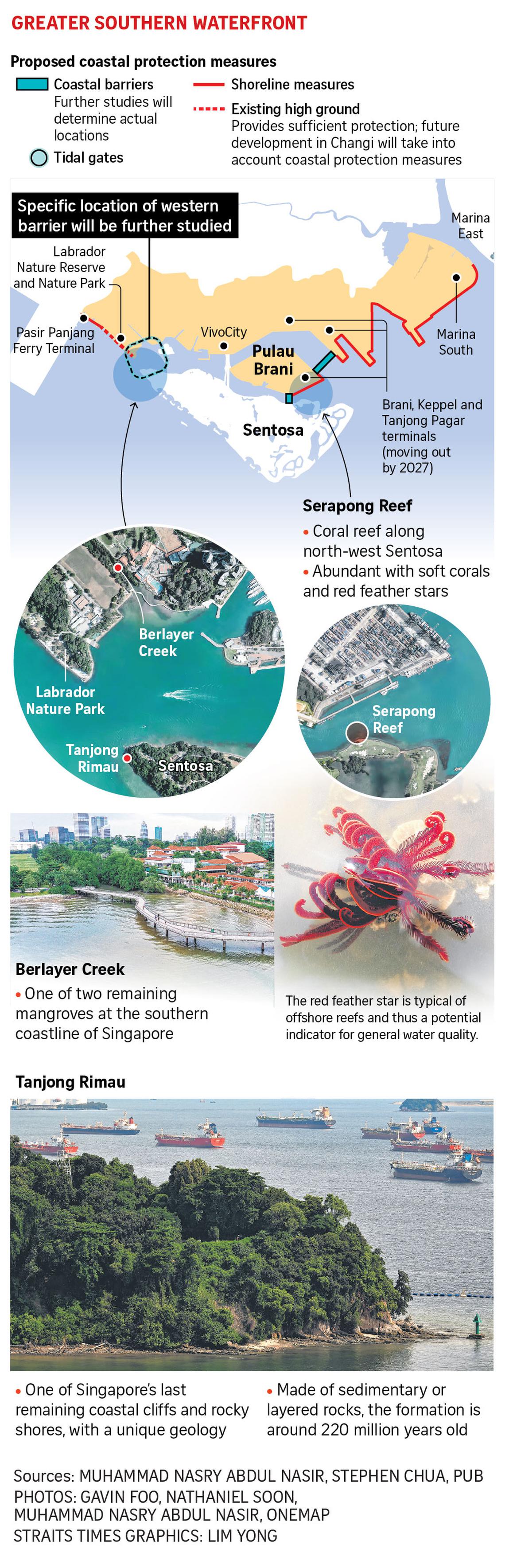
Nature experts have identified some habitats that are likely to be affected by construction and changes to water flow. They include Serapong Reef and Tanjong Rimau on Sentosa, and the mangroves of Berlayer Creek in Labrador and Changi Creek.
Three coastal barriers are expected to connect the western and eastern ends of Sentosa to the mainland. Each comprises a series of gates across the water channels that will remain open to allow vessels to pass except in extreme weather .
Two of the coastal barriers are expected to link mainland Singapore, around Tanjong Pagar Terminal, to Pulau Brani, and from Brani to the north-west coast of Sentosa.
An artist’s impression of a possible coastal barrier which also provides enhanced transport connectivity between Sentosa and Pulau Brani.
PHOTO: PUB
Their design will be further refined in the next couple of years.
Mr Muhammad Nasry Abdul Nasir, executive director of the Singapore Youth Voices for Biodiversity, is concerned that the barrier across Brani and Sentosa would cut through Serapong Reef, which runs along the north-west coast of the resort island.
Serapong Reef runs along the north-west coast of Sentosa.
PHOTO: ONEMAP
Sediment washed into the sea or from construction works could settle on the corals, potentially smothering parts of the reef. With water flow confined through the barrier’s gates, water movement across the channel may change, he noted.
“Corals like stronger currents because it keeps them clean,” said Mr Nasry, adding that Serapong is also home to many soft corals and a large number of red feather stars.
The flamboyant cousin of sea stars, the red feather star has brittle arms that resemble bird feathers.
“Seeing one feather star at a shore is already very impressive. I saw at least 25 of them during a survey at Serapong two months ago,” Mr Nasry recalled.
Serapong is home to a large number of red feather stars.
PHOTO: MUHAMMAD NASRY ABDUL NASIR
On the western side of Sentosa, the third coastal barrier will anchor on a spot on the mainland that will be determined following environmental impact studies.
Building the barrier at the narrowest parts of the channel may be most straightforward, but could risk impacting two key nature spots – Tanjong Rimau on the western coast of Sentosa, and Labrador Nature Reserve’s Berlayer Creek.
Tanjong Rimau hosts one of Singapore’s last remaining coastal cliffs and a rocky shore. Its geology features the sedimentary or layered rock formation of the Southern Islands.
Its rocks are about 220 million years old, formed from the overlapping layers of coarse and fine sand and silts from an ancient river environment. Across the Southern Islands, Tanjong Rimau’s rocky outcrop is the largest and most accessible of its kind, said Dr Stephen Chua from the NTU Earth Observatory of Singapore.
“It would be great to have the (coastal) barrier away from this outcrop, which is already exposed to erosion and likely to be affected by nearby construction. Sentosa and our Southern Islands have good geological value and have the potential to be a Unesco-worthy geopark collectively,” said Dr Chua.
Berlayer Creek is home to one of two remaining mangrove patches in the south of Singapore.
Berlayer Creek is home to one of two remaining mangrove patches in the south of Singapore.
PHOTO: ONEMAP
Mr Nasry hopes that the western coastal barrier will be built farther away from the nature spaces of Berlayer and Bukit Chermin, andtowards the more urban Keppel areas. But this means the mangroves may be exposed to rising seas and storm surges, flooding the forests for longer.
Alternatively, if some land is set aside for them to retreat and colonise inland, the mangroves can continue surviving. Mangroves can serve as a living defence against rising sea levels as their roots trap sediment from the tides, allowing them to keep pace with rising seas.
Assistant Professor Gary Lei from the NUS Department of Civil and Environmental Engineering added that the coastal barriers should be built using precast components where possible to reduce construction disruptions at sea.
The amount of suspended sediments and oxygen should also be tracked, with construction paused during coral spawning season.
Over in Changi, some coastal protection measures involve building several tidal gates along the far eastern coastline. Tidal gates built at canal outlets will be closed during high tide and extreme coastal weather to keep seawater out.
Nature groups have expressed concern about the impact of a tidal gate near the mangroves at Changi Creek. PUB is now looking at installing the gate farther downstream of the creek near Telok Paku Road, but issues remain.
Nature groups have expressed concern about the impact of a tidal gate near the mangroves at Changi Creek.
PHOTO: ONEMAP
With higher sea levels, the tidal gate may need to be closed more frequently, said MrLester Tan, chairman of the Marine Conservation Group at Nature Society Singapore. This would cut off the natural ebb and flow of waves that bring nutrients and sediment to the mangroves, as well as transport seedlings, affecting the forest’s long-term health, he added.
Prof Lei suggested building a tidal gate with multiple panels across the channel. While the gate is closed, the bottom panels could hover just above the sea bed so that some water can move in and out of the creek. This can also prevent silt from building up.
Ms Hazel Khoo, director of PUB’s coastal protection department, told The Straits Times that in its next phase of studies, PUB will work with relevant agencies , including the National Parks Board, to better understand and address any potential impacts on biodiversity.
“We will also engage stakeholders, including nature groups, and conduct environmental impact assessments to assess the potential impacts and develop appropriate mitigating measures before construction commences,” she added.
Nature Society’s Mr Tan said that as Singapore fortifies its shores in the next few decades, its entire coastline will be busy with construction work , including reclamation .
“The developments can be heavy-impact , impacting all shorelines at the same time. There will be no time for (habitat) recovery... Unfortunately, it is quite devastating for the blue spaces.
“It really depends on how we can phase the different developments for marine life to find a temporary new home each time.”
Read full article on The Straits Times - Singapore
Singapore

One-stop lifestyle app dedicated to making life in Singapore a breeze!


 English
 简体中文
简体中文
Comments
Leave a comment in Nestia App