See How Fast the Floodwaters Rose Along the Guadalupe River
July 7, 2025
Share full article
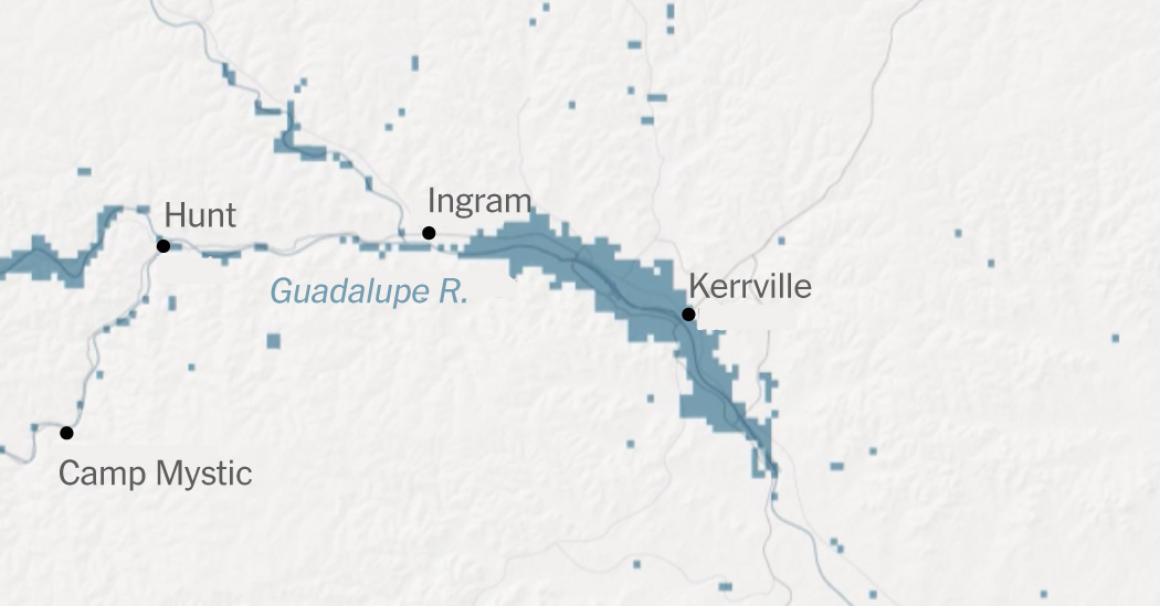
Areas that experienced flooding
Texas
Ingram
Map area
Hunt
Guadalupe River
Kerrville
Camp Mystic
Comfort
Center Point
5 miles
N
Camp Mystic
Hunt
Ingram
Guadalupe R.
Kerrville
Center Point
Comfort
Texas
Map area
5 miles
Texas
Map area
Ingram
Hunt
Guadalupe River
Kerrville
Camp Mystic
Comfort
Center Point
5 miles
Source: Flooding data via Floodbase
Note: Map shows areas with any level of estimated flooding. Localized flooding may be underrepresented.
In the early hours of July 4, floods swept through Hill Country, a region of Central Texas also known as “Flash Flood Alley.” Its propensity for high levels of rainfall combined with thin soil, exposed bedrock and steep terrain make it especially vulnerable. Rainfall gets funneled through the hilly terrain and canyons into the valleys of the region.
By 1 a.m. Friday, the Weather Service said a very dangerous flash flood event was unfolding in Kerr County, and rainfall rates were reaching up to three to four inches an hour with no indication of easing. The Guadalupe River rose 20 feet in three hours, according to data from a river gauge near Hunt. By 10 a.m., it swelled in the town of Comfort, surging to 34 feet from three feet in about 90 minutes.
In under 10 hours, from the late evening of July 3 to the pre-dawn hours of July 4, the flow rate of the Guadalupe River went from that of a small stream you could wade across (about 10 cubic feet per second), to a raging and destructive torrent of 120,000 cubic feet per second, according to a New York Times analysis. That's greater than the average flow rate across Niagara Falls.
The floods washed away cabins, R.V.s and cars and toppled down large trees. In its rush downstream, the river ravaged Camp Mystic, a girls’ summer camp in Kerr County, where at least 27 campers and counselors were killed in the floods.
The flooded river near Camp Mystic.
Carter Johnston for the New York Times
Crews work to clear debris from a bridge after the floods.
Carter Johnston for The New York Times
A destroyed car at Louise Hays Park in Kerrville, after the floods.
Jordan Vondehaar for The New York Times
A large truck is impaled onto a tree after the floods.
Jim Vondruska/Getty Images
A search and rescue crew prepares for operations.
Eric Vryn/Getty Images
At least 75 of those killed in the floods were in Kerr County, northwest of San Antonio, authorities said. Other people were killed in Travis County, Burnet County, Kendall County, Williamson County and Tom Green County.
Share full article
……Read full article on The New York Times-US
America Flood News

One-stop lifestyle app dedicated to making life in Singapore a breeze!


 English
 简体中文
简体中文
Comments
Leave a comment in Nestia App