What Is the U.N. Resolution That Tried and Failed to Keep the Peace in Lebanon?
A 2006 resolution by the United Nations Security Council ended the previous Israel-Hezbollah war but failed to keep the peace. Now, diplomats are fighting an uphill battle to revive the measure and pull the Middle East back from the brink of all-out war.
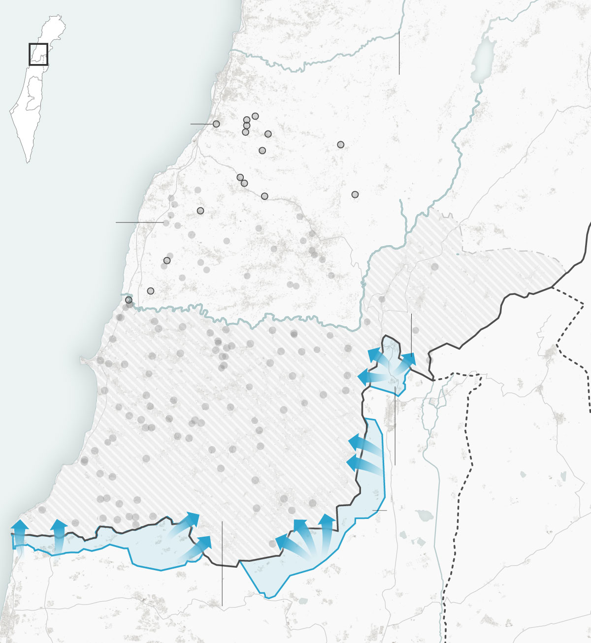
U.N. Security Council Resolution 1701, which sought to create a demilitarized zone in southern Lebanon, has not prevented fighting between Israel and Hezbollah, the Iran-backed militia group.
The cost of 1701’s failure is easy to see: Tens of thousands of people have fled their homes in northern Israel to escape Hezbollah rocket fire. And Israel’s military campaign against Hezbollah has set off a humanitarian crisis in Lebanon, displacing more than one million people and killing more than 2,400 over the past year, most of them in the past few weeks, according to Lebanon’s health ministry.
On Oct. 1, Israel invaded Lebanon yet again, in an attempt to create the secure buffer zone that 1701 had promised to ensure.
“If the State of Lebanon and the world cannot keep Hezbollah away from our border, we have no choice but to do so ourselves,” Rear Adm. Daniel Hagari, the Israeli military’s chief spokesman, said on Oct. 1, shortly after announcing the ground invasion.Here’s what you need to understand about the U.N. resolution, why it failed and the difficult road ahead to ending the current conflict in Lebanon.
Lebanon
Awali River
Map
Area
Med.
Sea
Israel told residents
to move north of
the Awali River
Towns Israel told people to leave
on Tuesday
Israel
Towns Israel has
told residents
to leave
Nabatieh
Where evidence of
Israeli forces is visible
in satellite imagery
Lebanon
Litani River
Abbasiyeh
Odaisseh
Military zones
closed by
Israel
Maroun
al-Ras
Naqoura
Golan
Heights
Yaroun
Israel
U.N. buffer zone set in 2006
5 miles
Awali River
Lebanon
Israel told residents
to move north of
the Awali River
Map
Area
Towns Israel
told people to
leave on Tuesday
Israel
Where evidence of
Israeli forces is visible
in satellite imagery
Towns Israel
has told
residents
to leave
Litani River
Odaisseh
Med.
Sea
Lebanon
Military
zones
closed by
Israel
Maroun
al-Ras
Naqoura
Yaroun
Israel
U.N. buffer zone
set in 2006
5 miles
Note: Crossing locations are based on New York Times analysis of satellite imagery from Planet Labs.
Sources: Israeli military, United Nations Interim Force In Lebanon, OpenStreetMap
By Josh Holder and Lauren Leatherby
Thank you for your patience while we verify access. If you are in Reader mode please exit and log into your Times account, or subscribe for all of The Times.
Thank you for your patience while we verify access.
Already a subscriber? Log in.
Want all of The Times? Subscribe.
……Read full article on The New York Times-World
Politics Middle East Israel News

One-stop lifestyle app dedicated to making life in Singapore a breeze!


 English
 简体中文
简体中文
Comments
Leave a comment in Nestia App